|
Earth
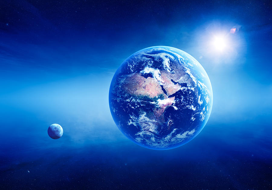
Earth is the third planet from the Sun and the only astronomical object known to harbor life. According to radiometric dating estimation and other evidence, Earth formed over 4.5 billion years ago. Earth's gravity interacts with other objects in space, especially the Sun and the Moon, which is Earth's only natural satellite. Earth orbits around the Sun in 365.256 solar days, a period known as an Earth sidereal year. During this time, Earth rotates about its axis 366.256 times, that is, a sidereal year has 366.256 sidereal days.
Earth's axis of rotation is tilted with respect to its orbital plane, producing seasons on Earth. The gravitational interaction between Earth and the Moon causes tides, stabilizes Earth's orientation on its axis, and gradually slows its rotation. Earth is the densest planet in the Solar System and the largest and most massive of the four rocky planets.
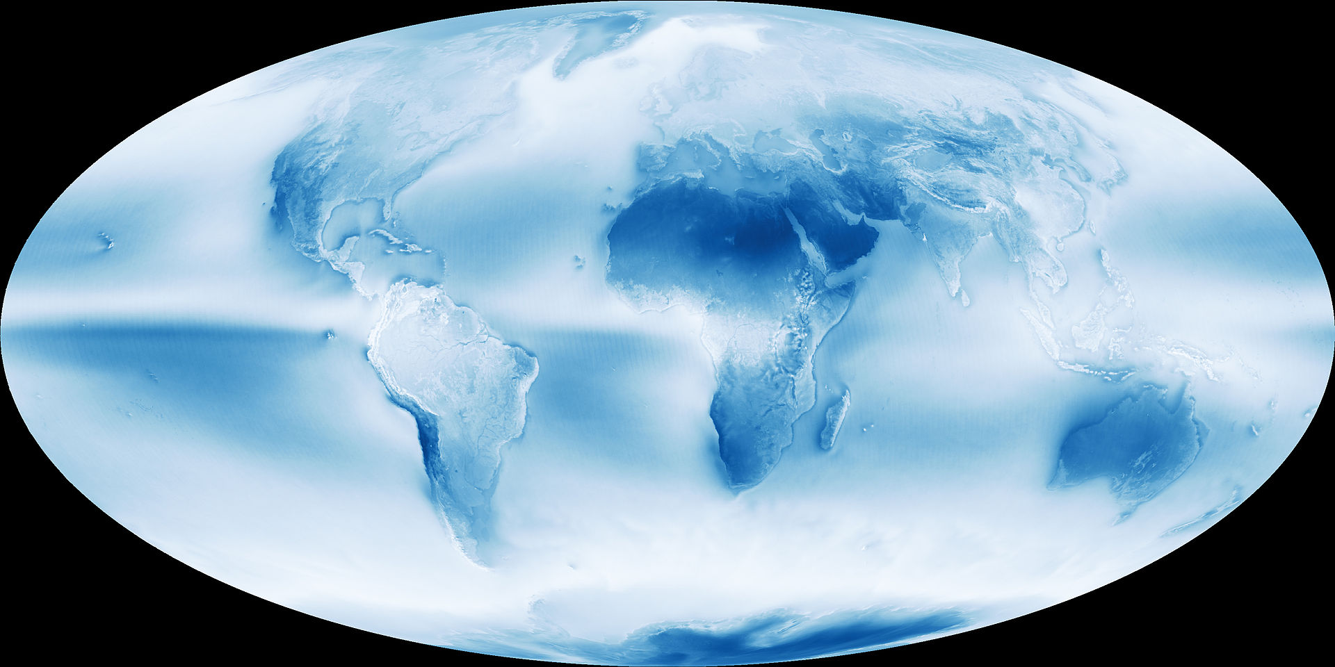
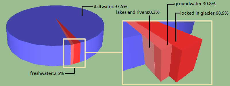
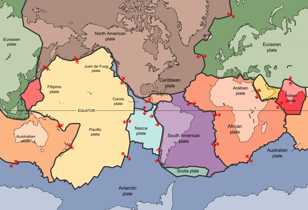
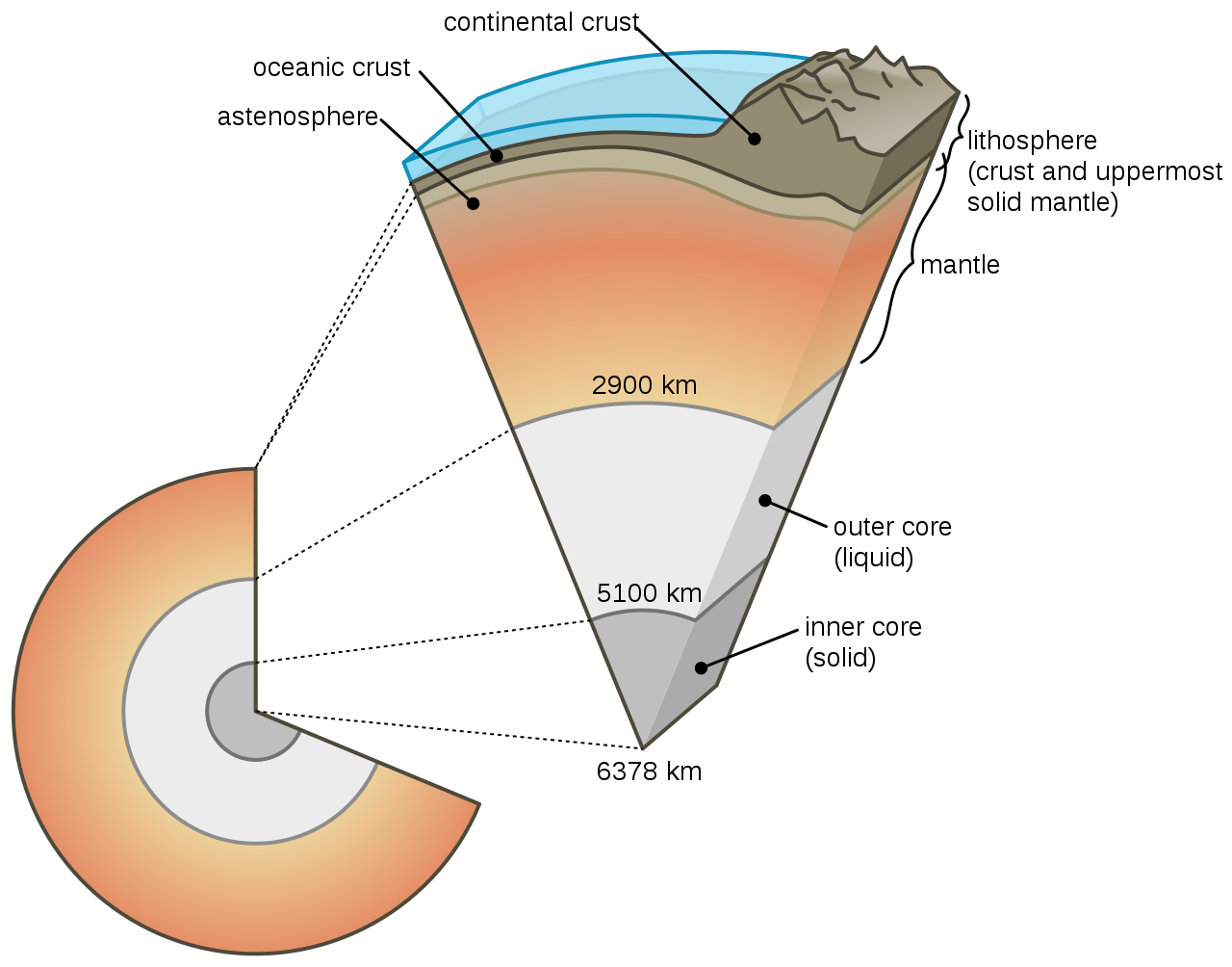
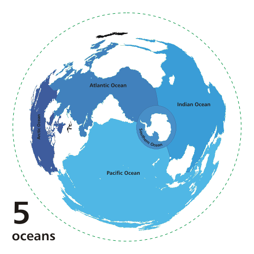
Earth's outer layer (lithosphere) is divided into several rigid tectonic plates that migrate across the surface over many millions of years. About 29% of Earth's surface is land consisting of continents and islands. The remaining 71% is covered with water, mostly by oceans but also lakes, rivers and other fresh water, which all together constitute the hydrosphere. The majority of Earth's polar regions are covered in ice, including the Antarctic ice sheet and the sea ice of the Arctic ice pack. Earth's interior remains active with a solid iron inner core, a liquid outer core that generates Earth's magnetic field, and a convecting mantle that drives plate tectonics.
Within the first billion years of Earth's history, life appeared in the oceans and began to affect Earth's atmosphere and surface, leading to the proliferation of anaerobic and, later, aerobic organisms. Some geological evidence indicates that life may have arisen as early as 4.1 billion years ago. Since then, the combination of Earth's distance from the Sun, physical properties and geological history have allowed life to evolve and thrive. In the history of life on Earth, biodiversity has gone through long periods of expansion, occasionally punctuated by mass extinctions. Over 99% of all species that ever lived on Earth are extinct. Estimates of the number of species on Earth today vary widely; most species have not been described. Over 7.7 billion humans live on Earth and depend on its biosphere and natural resources for their survival. (W)
📂 DATA
DATA
| Designations |
|
Terra, Tellus, Gaia, Gaea, the World, the Globe |
| Adjectives |
Earthly, terrestrial, terran, tellurian |
| Orbital characteristics |
| Epoch J2000 |
| Aphelion |
152100000 km
(94500000 mi; 1.017 AU) |
| Perihelion |
147095000 km
(91401000 mi; 0.98327 AU) |
|
149598023 km
(92955902 mi; 1.00000102 AU) |
| Eccentricity |
0.0167086 |
|
365.256363004 d
(1.00001742096 yr) |
|
29.78 km/s
(107200 km/h; 66600 mph) |
|
358.617° |
| Inclination |
|
|
−11.26064° to J2000 ecliptic |
|
114.20783° |
| Satellites |
|
| Physical characteristics |
Mean radius |
6371.0 km (3958.8 mi) |
|
6378.1 km (3963.2 mi) |
|
6356.8 km (3949.9 mi) |
| Flattening |
0.0033528
1/ 298.257222101 (ETRS89) |
| Circumference |
|
|
- 510072000 km2 (196940000 sq mi)
- 148940000 km2 land (57510000 sq mi; 29.2%)
- 361132000 km2 water (139434000 sq mi; 70.8%)
|
| Volume |
1.08321×10¹² km3 ( 2.59876×10¹¹ cu mi) |
| Mass |
5.97237×1024 kg ( 1.31668×1025 lb)
( 3.0×10⁻⁶ M☉) |
|
5.514 g/cm3 (0.1992 lb/cu in) |
|
9.80665 m/s2 ( 1 g; 32.1740 ft/s2) |
|
0.3307 |
|
11.186 km/s
(40270 km/h; 25020 mph) |
|
0.99726968 d
(23h 56m 4.100s) |
Equatorial rotation velocity |
0.4651 km/s
(1674.4 km/h; 1040.4 mph) |
|
23.4392811° |
| Albedo |
|
| Surface temp. |
min |
mean |
max |
| Kelvin |
184 K |
287.16 K (years 1961–1990) |
330 K |
| Celsius |
−89.2 °C |
14.0 °C (years 1961–1990) |
56.7 °C |
| Fahrenheit |
−128.5 °F |
57.2 °F (years 1961–1990) |
134.0 °F |
|
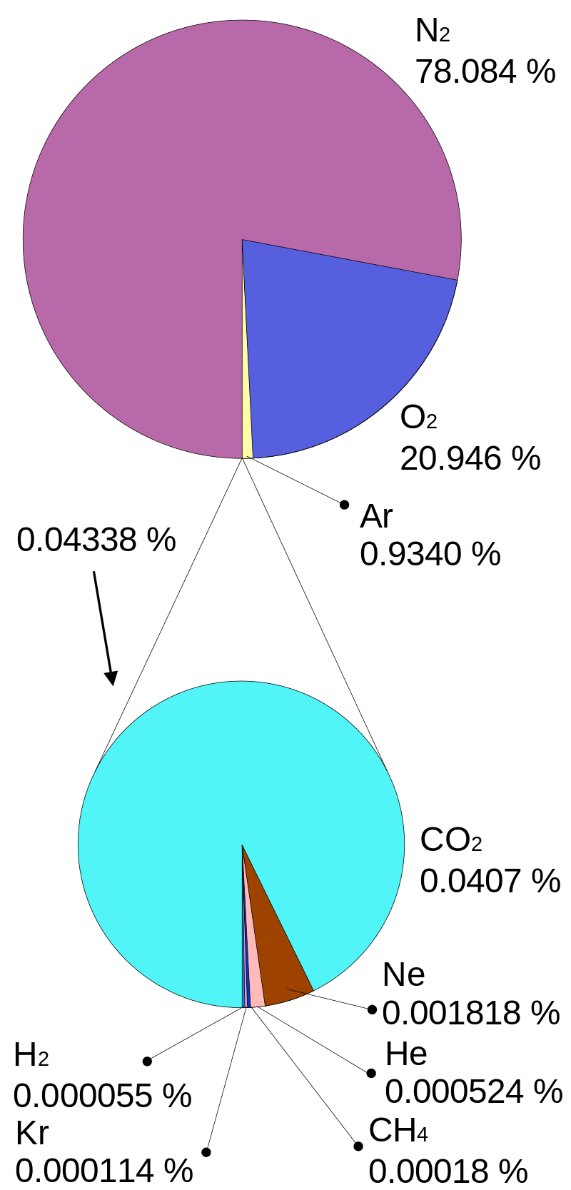
| Atmosphere |
|
101.325 kPa (at MSL) |
| Composition by volume |
|
|

|
|
|
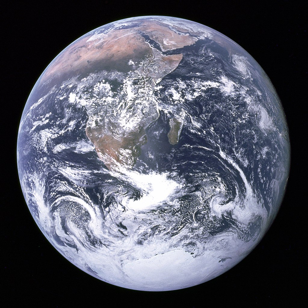
"The Blue Marble" photograph of Earth, taken by the Apollo 17 mission. The Arabian peninsula, Africa and Madagascar lie in the upper half of the disc, whereas Antarctica is at the bottom. |
|
|
|
|
History of Earth
The history of Earth concerns the development of planet Earth from its formation to the present day. Nearly all branches of natural science have contributed to understanding of the main events of Earth's past, characterized by constant geological change and biological evolution. (W)
📂History of Earth
History of Earth (W)
The history of Earth concerns the development of planet Earth from its formation to the present day. Nearly all branches of natural science have contributed to understanding of the main events of Earth's past, characterized by constant geological change and biological evolution.
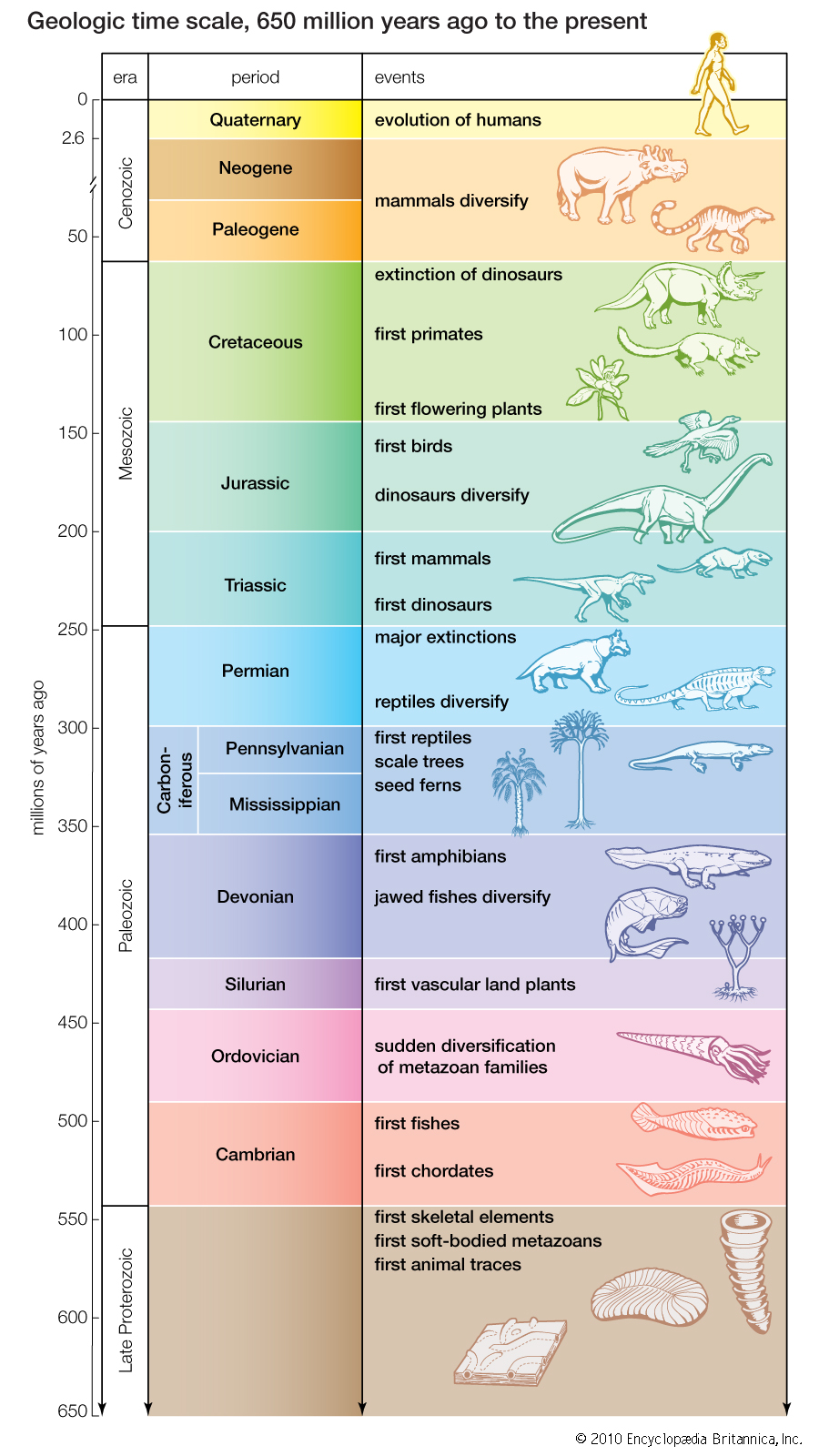
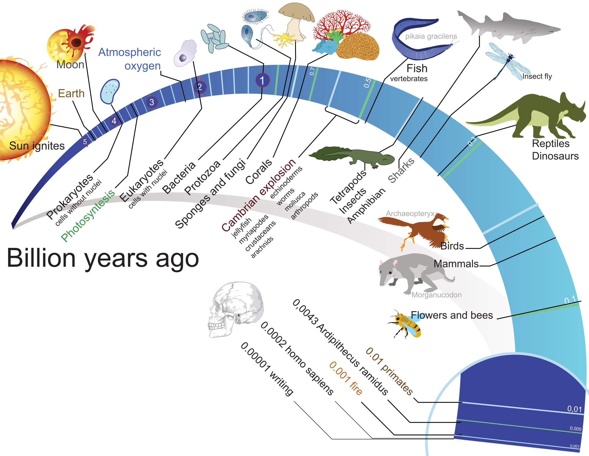
The geological time scale (GTS), as defined by international convention, depicts the large spans of time from the beginning of the Earth to the present, and its divisions chronicle some definitive events of Earth history. (In the graphic: Ga means "billion years ago"; Ma, "million years ago".) Earth formed around 4.54 billion years ago, approximately one-third the age of the universe, by accretion from the solar nebula. Volcanic outgassing probably created the primordial atmosphere and then the ocean, but the early atmosphere contained almost no oxygen. Much of the Earth was molten because of frequent collisions with other bodies which led to extreme volcanism. While the Earth was in its earliest stage (Early Earth), a giant impact collision with a planet-sized body named Theia is thought to have formed the Moon. Over time, the Earth cooled, causing the formation of a solid crust, and allowing liquid water on the surface.
The Hadean eon represents the time before a reliable (fossil) record of life; it began with the formation of the planet and ended 4.0 billion years ago. The following Archean and Proterozoic eons produced the beginnings of life on Earth and its earliest evolution. The succeeding eon is the Phanerozoic, divided into three eras: the Palaeozoic, an era of arthropods, fishes, and the first life on land; the Mesozoic, which spanned the rise, reign, and climactic extinction of the non-avian dinosaurs; and the Cenozoic, which saw the rise of mammals. Recognizable humans emerged at most 2 million years ago, a vanishingly small period on the geological scale.
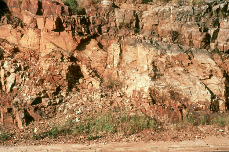
The earliest undisputed evidence of life on Earth dates at least from 3.5 billion years ago, during the Eoarchean Era, after a geological crust started to solidify following the earlier molten Hadean Eon. There are microbial mat fossils such as stromatolites found in 3.48 billion-year-old sandstone discovered in Western Australia. Other early physical evidence of a biogenic substance is graphite in 3.7 billion-year-old metasedimentary rocks discovered in southwestern Greenland as well as "remains of biotic life" found in 4.1 billion-year-old rocks in Western Australia. According to one of the researchers, "If life arose relatively quickly on Earth … then it could be common in the universe."
Photosynthetic organisms appeared between 3.2 and 2.4 billion years ago and began enriching the atmosphere with oxygen. Life remained mostly small and microscopic until about 580 million years ago, when complex multicellular life arose, developed over time, and culminated in the Cambrian Explosion about 541 million years ago. This sudden diversification of life forms produced most of the major phyla known today, and divided the Proterozoic Eon from the Cambrian Period of the Paleozoic Era. It is estimated that 99 percent of all species that ever lived on Earth, over five billion, have gone extinct. Estimates on the number of Earth's current species range from 10 million to 14 million, of which about 1.2 million are documented, but over 86 percent have not been described. However, it was recently claimed that 1 trillion species currently live on Earth, with only one-thousandth of one percent described.
The Earth's crust has constantly changed since its formation, as has life since its first appearance. Species continue to evolve, taking on new forms, splitting into daughter species, or going extinct in the face of ever-changing physical environments. The process of plate tectonics continues to shape the Earth's continents and oceans and the life they harbor. Human activity is now a dominant force affecting global change, harming the biosphere, the Earth's surface, hydrosphere, and atmosphere with the loss of wild lands, over-exploitation of the oceans, production of greenhouse gases, degradation of the ozone layer, and general degradation of soil, air, and water quality. |
|
|
|
|
|
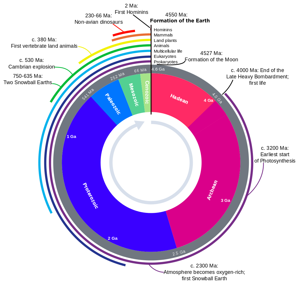
Earth's history with time-spans of the eons to scale. |
|
|
|
|
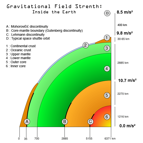
Earth’s crust
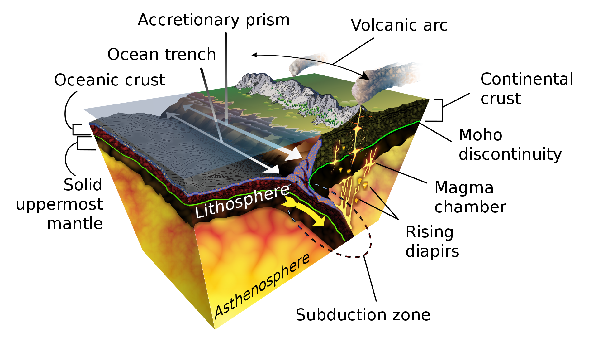
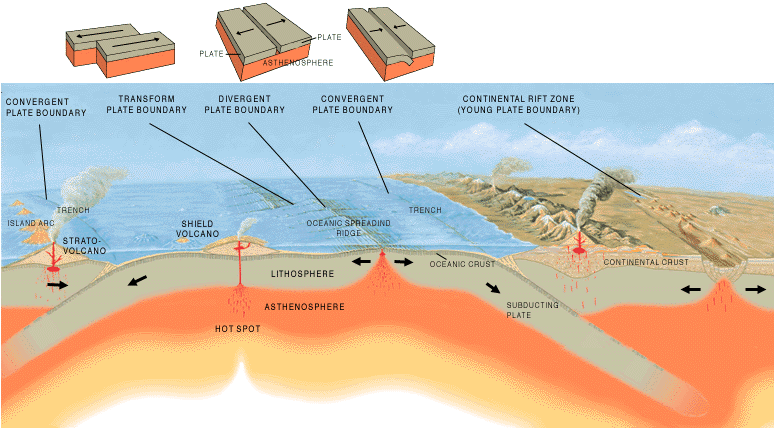
Earth's crust is a thin shell on the outside of Earth, accounting for less than 1% of Earth's volume. It is the top component of lithosphere: a division of Earth's layers that includes the crust and the upper part of the mantle. The lithosphere is broken into tectonic plates that move, allowing heat to escape from the interior of the Earth into space.
The crust lies on top of the mantle, a configuration that is stable because the upper mantle is made of peridotite and so is significantly more dense than the crust. The boundary between the crust and mantle is conventionally placed at the Mohorovičić discontinuity, a boundary defined by a contrast in seismic velocity.
The crust of Earth is of two distinct types:
- Oceanic: 5 km (3 mi) to 10 km (6 mi) thick and composed primarily of denser, more mafic rocks, such as basalt, diabase, and gabbro.
- Continental: 30 km (20 mi) to 50 km (30 mi) thick and mostly composed of less dense, more felsic rocks, such as granite.
Because both continental and oceanic crust are less dense than the mantle below, both types of crust "float" on the mantle. This is isostasy, and it's also one of the reasons continental crust is higher than oceanic: continental is less dense and so "floats" higher. As a result, water pools in above the oceanic crust, forming the oceans.
The temperature of the crust increases with depth, reaching values typically in the range from about 200 °C (392 °F) to 400 °C (752 °F) at the boundary with the underlying mantle. The temperature increases by as much as 30 °C (54 °F) for every kilometer locally in the upper part of the crust, but the geothermal gradient is smaller in deeper crust. (W)
| Most Abundant Elements of Earth's Crust |
Approximate % by weight |
| O |
46.6 |
| Si |
27.7 |
| Al |
8.1 |
| Fe |
5.0 |
| Ca |
3.6 |
| Na |
2.8 |
| K |
2.6 |
| Mg |
1.5 |
|
|
|
|
|
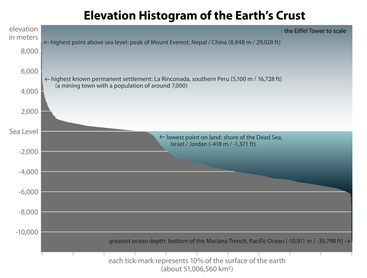
Elevation histogram showing the percentage of the Earth's surface above and below sea level. |
|
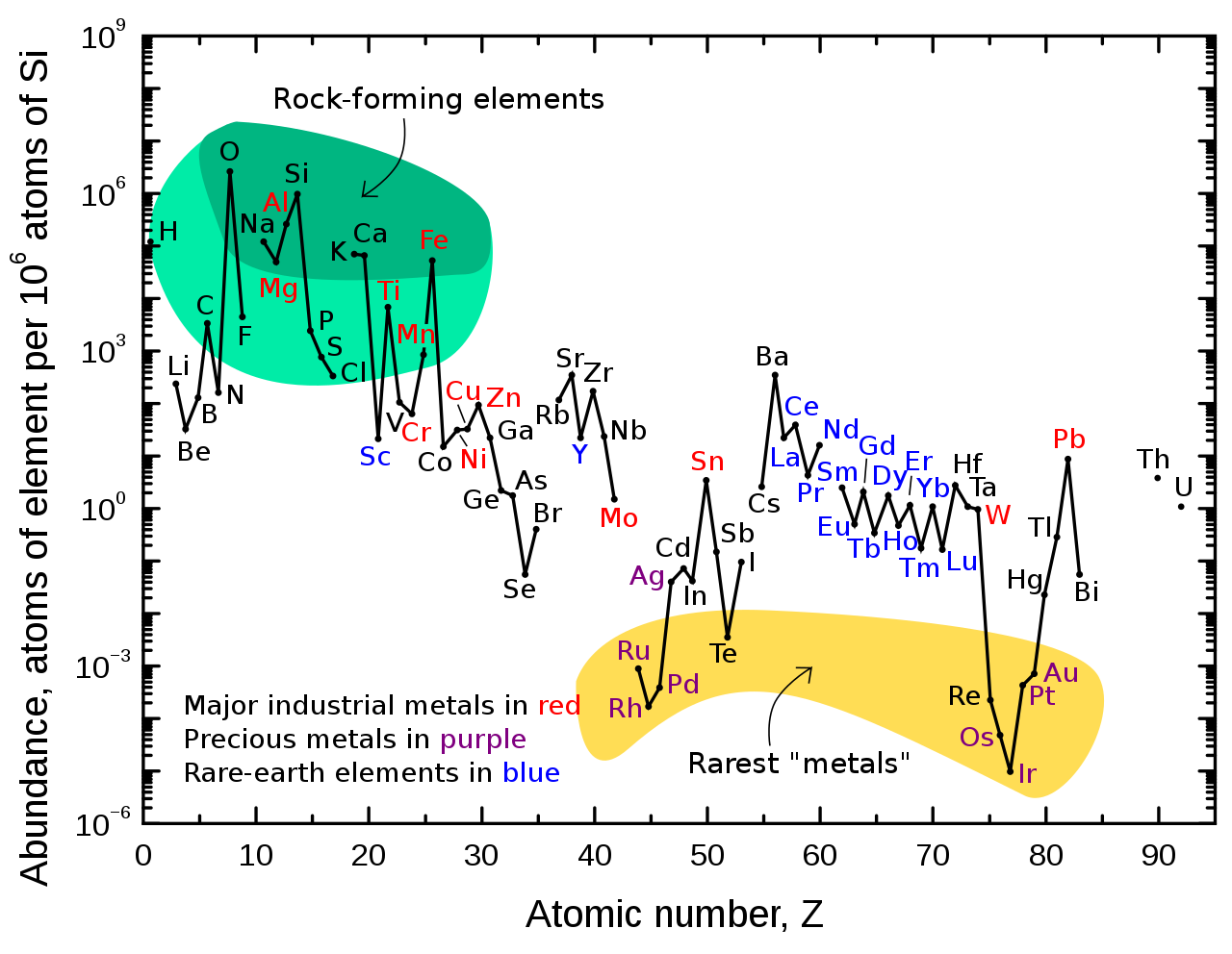
Abundance (atom fraction) of the chemical elements in Earth's upper continental crust as a function of atomic number. The rarest elements in the crust (shown in yellow) are not the heaviest, but are rather the siderophile (iron-loving) elements in the Goldschmidt classification of elements. These have been depleted by being relocated deeper into Earth's core. Their abundance in meteoroid materials is higher. Additionally, tellurium and selenium have been depleted from the crust due to formation of volatile hydrides.. |
|
|
|
|
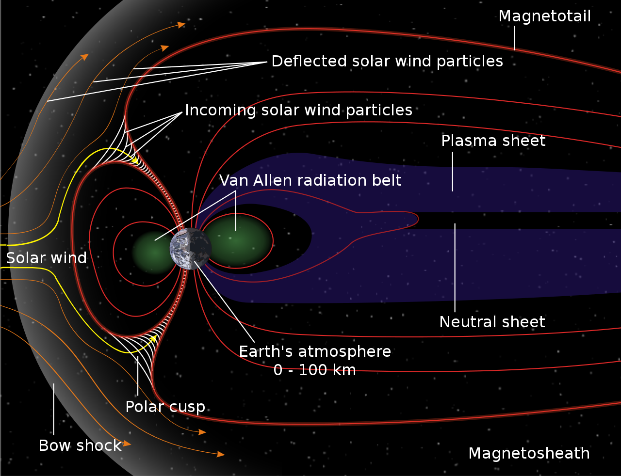
Earth’s magnetic field
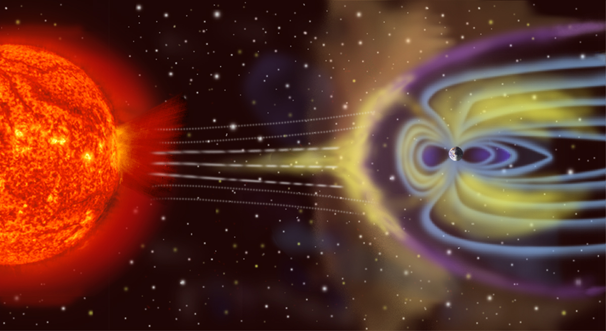
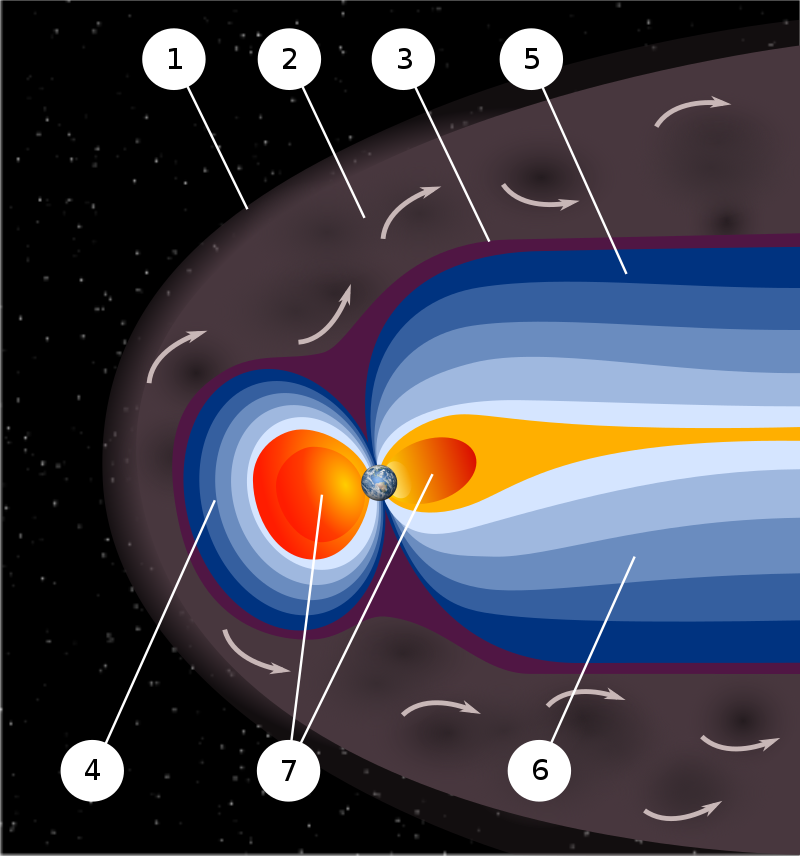
Earth's magnetic field, also known as the geomagnetic field, is the magnetic field that extends from the Earth's interior out into space, where it interacts with the solar wind, a stream of charged particles emanating from the Sun. The magnetic field is generated by electric currents due to the motion of convection currents of a mixture of molten iron and nickel in the Earth's outer core: these convection currents are caused by heat escaping from the core, a natural process called a geodynamo. The magnitude of the Earth's magnetic field at its surface ranges from 25 to 65 microteslas (0.25 to 0.65 gauss).As an approximation, it is represented by a field of a magnetic dipole currently tilted at an angle of about 11 degrees with respect to Earth's rotational axis, as if there were an enormous bar magnet placed at that angle through the center of the Earth. The North geomagnetic pole, which was in 2015 located on Ellesmere Island, Nunavut, Canada, in the northern hemisphere, is actually the south pole of the Earth's magnetic field, and conversely.
While the North and South magnetic poles are usually located near the geographic poles, they slowly and continuously move over geological time scales, but sufficiently slowly for ordinary compasses to remain useful for navigation. However, at irregular intervals averaging several hundred thousand years, the Earth's field reverses and the North and South Magnetic Poles respectively, abruptly switch places. These reversals of the geomagnetic poles leave a record in rocks that are of value to paleomagnetists in calculating geomagnetic fields in the past. Such information in turn is helpful in studying the motions of continents and ocean floors in the process of plate tectonics.
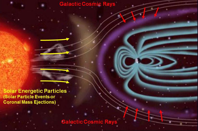
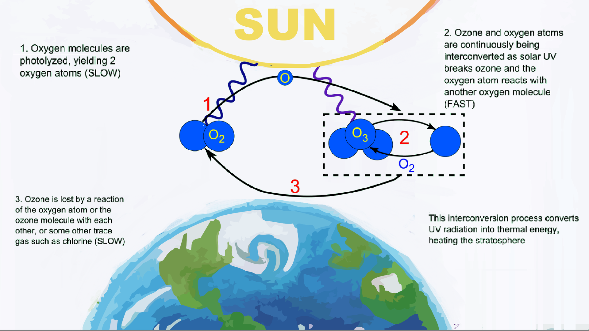
The magnetosphere is the region above the ionosphere that is defined by the extent of the Earth's magnetic field in space. It extends several tens of thousands of kilometers into space, protecting the Earth from the charged particles of the solar wind and cosmic rays that would otherwise strip away the upper atmosphere, including the ozone layer that protects the Earth from harmful ultraviolet radiation. (W)
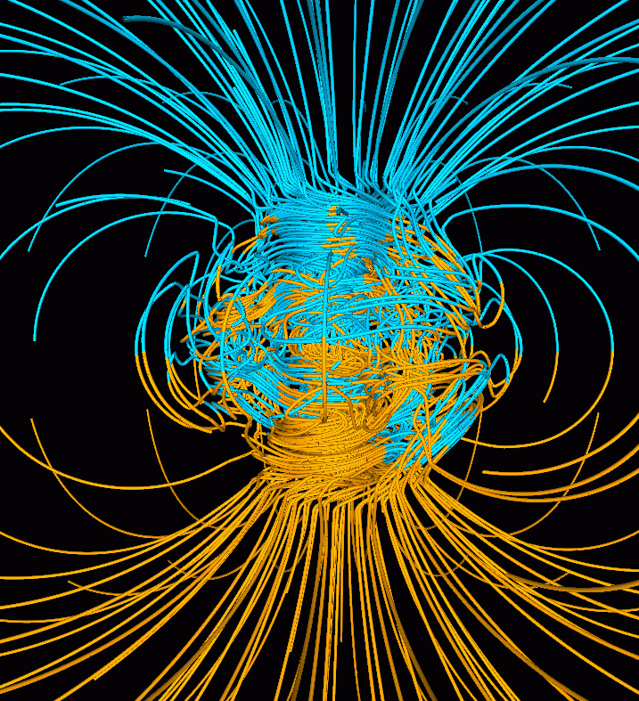
Computer simulation of the Earth's field in a period of normal polarity between reversals. The lines represent magnetic field lines, blue when the field points towards the center and yellow when away. The rotation axis of the Earth is centered and vertical. The dense clusters of lines are within the Earth's core. |
|
|
|
|
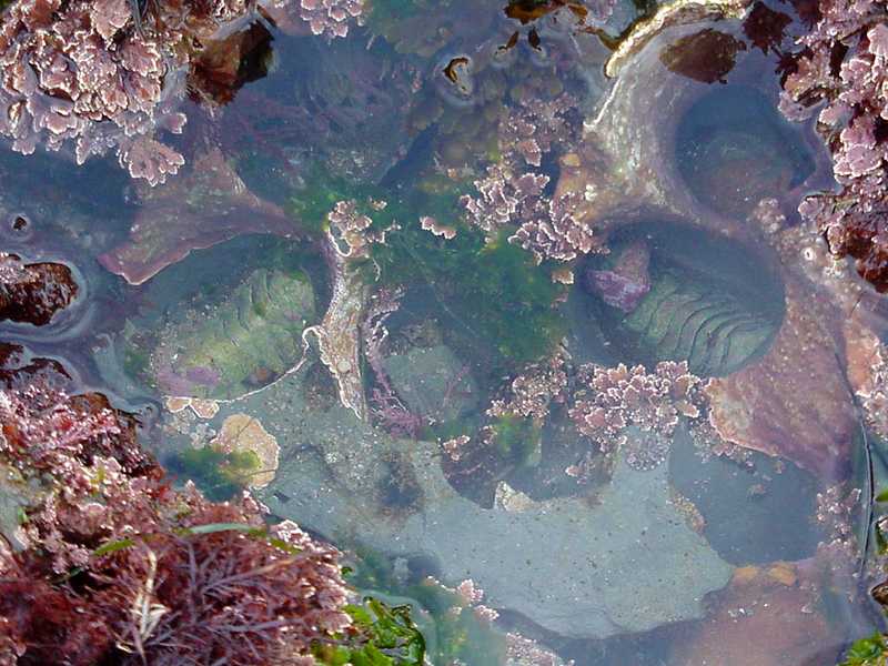
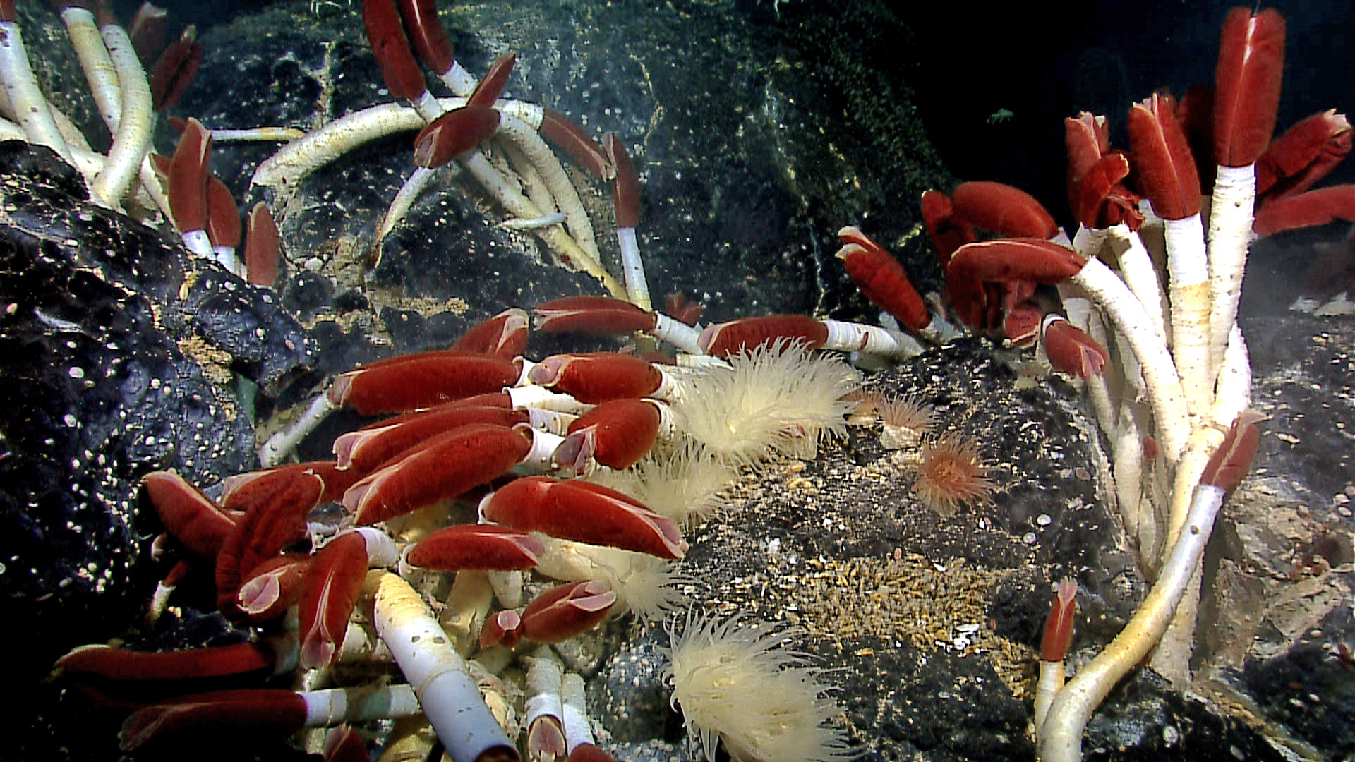
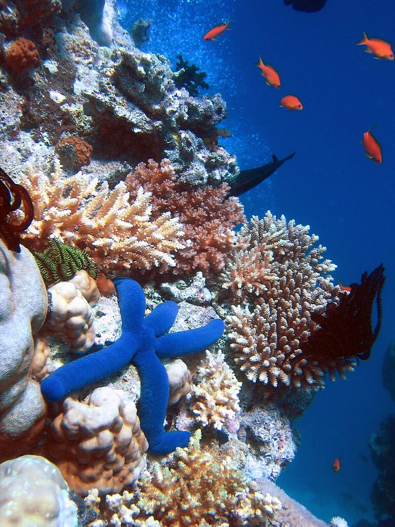
Ecosystem
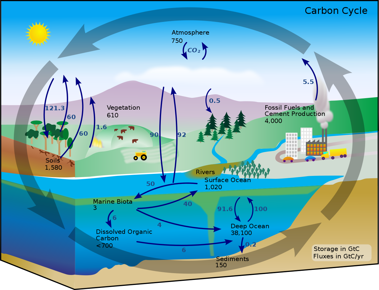
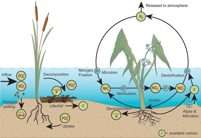
An ecosystem is a community of living organisms in conjunction with the nonliving components of their environment, interacting as a system. These biotic and abiotic components are linked together through nutrient cycles and energy flows. Energy enters the system through photosynthesis and is incorporated into plant tissue. By feeding on plants and on one another, animals play an important role in the movement of matter and energy through the system. They also influence the quantity of plant and microbial biomass present. By breaking down dead organic matter, decomposers release carbon back to the atmosphere and facilitate nutrient cycling by converting nutrients stored in dead biomass back to a form that can be readily used by plants and other microbes. (W)
📂 Ecosystem
Ecosystem (W)
An ecosystem is a community of living organisms in conjunction with the nonliving components of their environment, interacting as a system. These biotic and abiotic components are linked together through nutrient cycles and energy flows. Energy enters the system through photosynthesis and is incorporated into plant tissue. By feeding on plants and on one another, animals play an important role in the movement of matter and energy through the system. They also influence the quantity of plant and microbial biomass present. By breaking down dead organic matter, decomposers release carbon back to the atmosphere and facilitate nutrient cycling by converting nutrients stored in dead biomass back to a form that can be readily used by plants and other microbes.
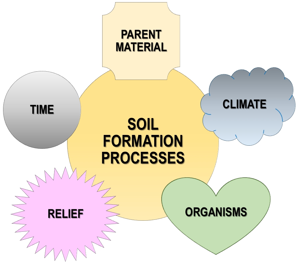
Ecosystems are controlled by external and internal factors. External factors such as climate, parent material which forms the soil and topography, control the overall structure of an ecosystem but are not themselves influenced by the ecosystem. Unlike external factors, internal factors are controlled, for example, decomposition, root competition, shading, disturbance, succession, and the types of species present.
Ecosystems are dynamic entities—they are subject to periodic disturbances and are in the process of recovering from some past disturbance.Ecosystems in similar environments that are located in different parts of the world can end up doing things very differently simply because they have different pools of species present. Internal factors not only control ecosystem processes but are also controlled by them and are often subject to feedback loops.
Resource inputs are generally controlled by external processes like climate and parent material. Resource availability within the ecosystem is controlled by internal factors like decomposition, root competition or shading. Although humans operate within ecosystems, their cumulative effects are large enough to influence external factors like climate.
Biodiversity affects ecosystem functioning, as do the processes of disturbance and succession. Ecosystems provide a variety of goods and services upon which people depend. |
|
|
|
|
|
|
|
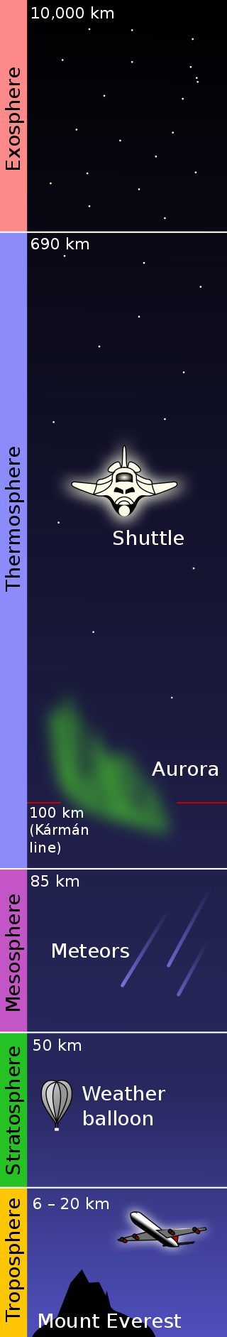
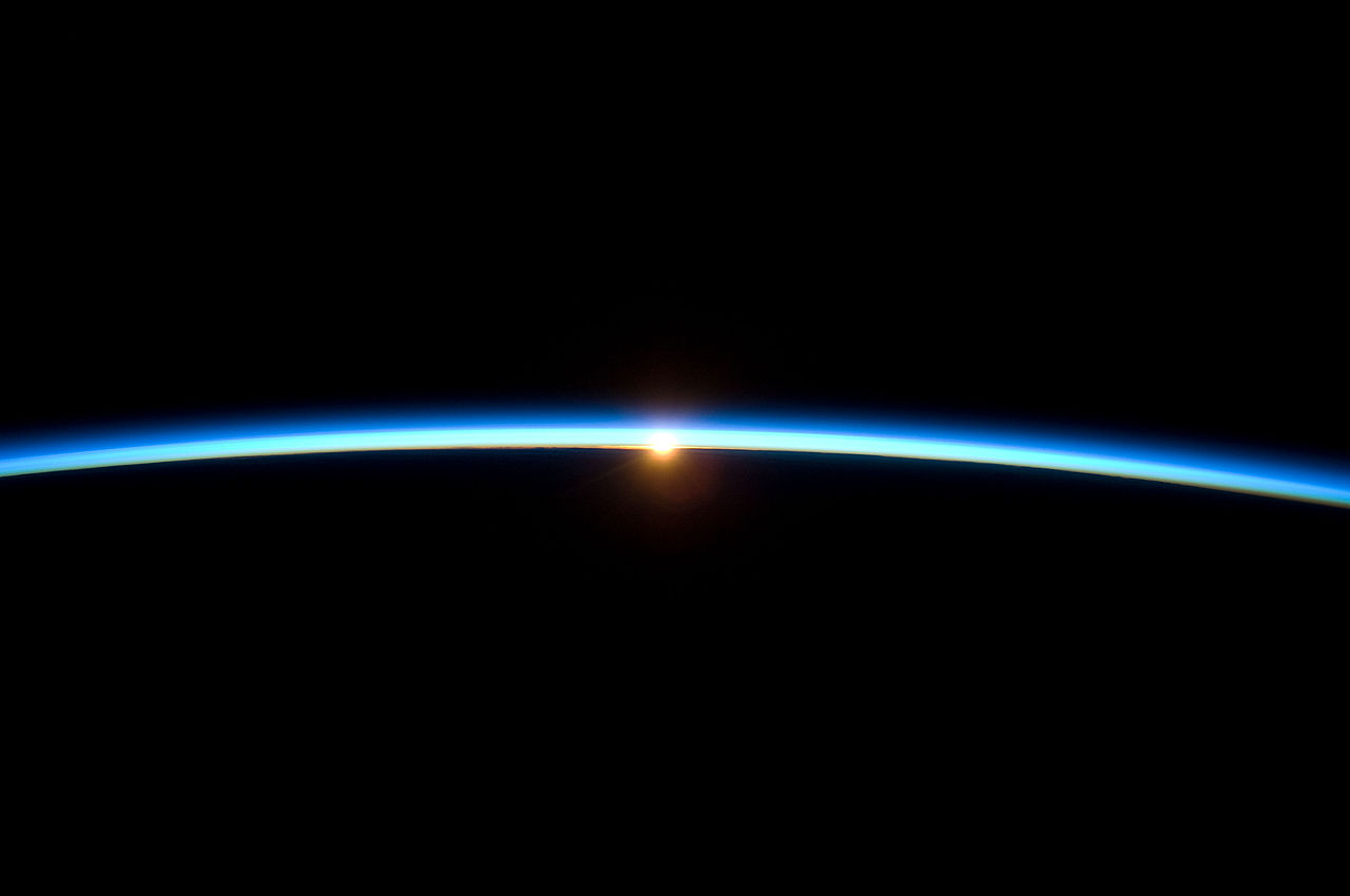
Exosphere
The exosphere (Ancient Greek: ἔξω éxō "outside, external, beyond", Ancient Greek: σφαῖρα sphaĩra "sphere") is a thin, atmosphere-like volume surrounding a planet or natural satellite where molecules are gravitationally bound to that body, but where the density is too low for them to behave as a gas by colliding with each other. In the case of bodies with substantial atmospheres, such as Earth's atmosphere, the exosphere is the uppermost layer, where the atmosphere thins out and merges with interplanetary space. It is located directly above the thermosphere. Very little is known about it due to lack of research. Mercury, the Moon and three Galilean satellites of Jupiter have surface boundary exospheres, which are exospheres without a denser atmosphere underneath. The gases that can be found in the Earth's exosphere are mostly hydrogen and carbon dioxide. (W)
|
|
| |
|
| Diagram showing the five primary layers of the Earth's atmosphere: exosphere, thermosphere, mesosphere, stratosphere, and troposphere. The layers are to scale. From the Earth's surface to the top of the stratosphere (50km) is just under 1% of Earth's radius. |
|
|
|
|
|

_(4_cm).png)


.jpg)

.png)
_-_Stephanopyxis_sp._-_630x_(14117161428).jpg)